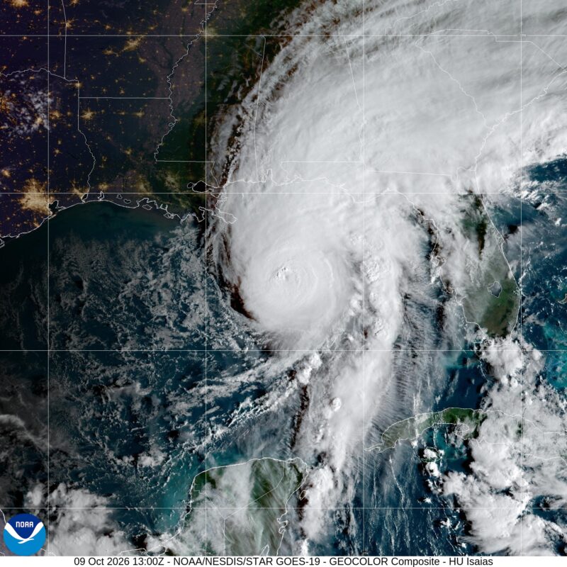
Isaias is a major hurricane, headed for the Gulf Coast
After the longest wait on record in the satellite era, this year’s Atlantic hurricane season has its first hurricane: Hurricane Isaias.
Isaias is now a powerful, major Category 3 hurricane with sustained winds up to 120 miles per hour (193 kph). The hurricane, as of 7 a.m. CDT Friday, October 9, is 245 miles (390 km) south of Pensacola, Florida. It’s taking aim at the Gulf Coast with landfall expected Friday night near the Alabama and Florida state line. Strong wind shear could weaken the storm before it makes landfall, but dangerous and life-threatening impacts are still expected in the form of up to 7 feet (2 meters) of storm surge and heavy rain of more than 6 inches (15 cm) causing flash flooding. In addition, there’s the risk of hurricane-force winds and tornadoes on the eastern side of the storm.
Isaias formed as a tropical storm in the southwestern Gulf on Wednesday morning, October 7. By 10:30 p.m. CDT, it had strengthened into a hurricane, with maximum sustained winds of 75 miles per hour (120 km/h).
A life-threatening storm surge is expected on portions of the northern Gulf Coast, while dangerous hurricane-force winds are expected over portions of the Florida Panhandle, southern Alabama and southern Mississippi. Find NHC forecast updates here.
Nearly a record-breaking hurricane
Until Isaias, this year’s below-average hurricane season had seen only nine tropical storms and no hurricanes. The last Atlantic hurricane season that had no hurricanes was back in 1914. And this was in the pre-weather satellite era, when data and records were not as reliable. During the weather satellite era there has never been a hurricane season in the Atlantic with no hurricanes, and Isaias has made sure that trend continues.
According to Dr. Philip Klotzbach with Colorado State University, the latest first hurricane on record was October 8, 1905. So it seems Isaias missed out on that record by just a few hours. However, in the era of weather satellite observations, beginning in 1966, Hurricane Isaias is indeed the latest first Atlantic hurricane. On average, the first hurricane of the season forms around August 11th.
Isaias threats
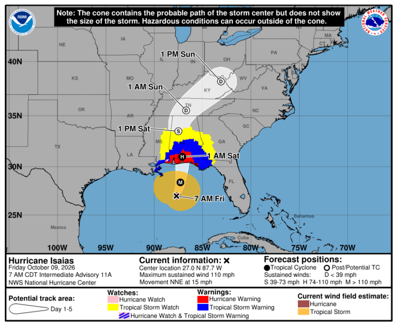
The National Hurricane Center says that life-threatening storm surge is possible for parts of the northern Gulf Coast. Up to 7 feet (2.1 meters) of storm surge — water pushed in from the ocean over dry land due to winds from a hurricane — is forecast from Ocean Springs, Mississippi, through Mobile Bay, Alabama, and out toward Indian Pass, Florida.
Additionally up to 5 feet (1.5 meters) of surge is possible from the mouth of the Mississippi River up toward Ocean Springs, Mississippi. Heavy rain is also possible, with up to 8 inches (20 cm) forecast to fall across Alabama and the Florida Panhandle. Hurricane-force winds are also expected across the Gulf Coast, especially near the point of landfall.
The forecast cone
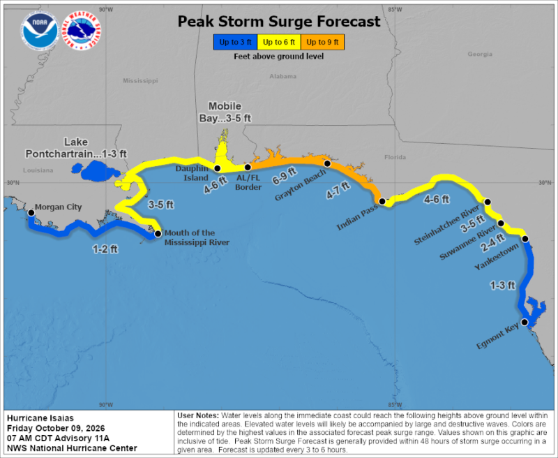
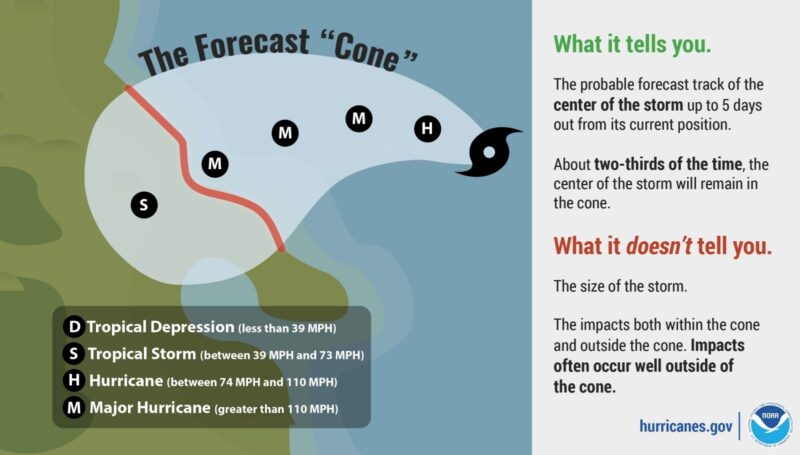
One of the most misunderstood aspects of hurricane forecasts is the forecast cone. The forecast cone, or track, shows where the center of the storm is expected to go. Historically, the center of the storm has remained inside the cone about 2/3 of the time, meaning that in roughly 1/3 of cases, the center can fall outside the cone.
Plus, the cone only represents the forecast uncertainty for the storm’s center. The hurricane itself is much larger, and its impacts can extend well beyond the cone. This means that dangerous weather can occur outside the forecast cone, even when the storm’s center remains within it.
This makes it important to get your weather information from a trusted source, such as the National Hurricane Center, your local National Weather Service office or a local television meteorologist you trust. Also, if any local emergency agencies call for you to evacuate, do not hesitate: immediately evacuate inland to escape the threat of storm surge flooding.
Bottom line: Hurricane Isaias has become the first hurricane of the 2026 Atlantic season. It is now a major hurricane and should make landfall around midnight tonight near the Alabama/Florida state line.
Read more: Atlantic hurricane season sets a record: No hurricanes yet!